

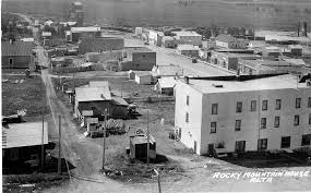
The most important geographer of nineteenth century western North America did not work from a university. He worked from a fur trade post on the Clearwater River near where it meets the North Saskatchewan. His name was David Thompson. His base of operations through much of the period from 1799 to 1812 was Rocky Mountain House. The maps he produced from that base remained the standard reference for western North American geography for the better part of a century.
David Thompson clocks in
Thompson was Welsh-born, trained originally with the Hudson’s Bay Company, and switched to the North West Company in 1797. The NWC put him to work doing exactly what his training prepared him for. Survey the country, run the instruments, write down what you find, and bring back maps the company can use to push west. Rocky Mountain House became his principal working base because the Clearwater and the North Saskatchewan together opened access to the Athabasca, the Howse Pass, and the upper Columbia.
The work that mattered
Two of Thompson’s biggest field accomplishments ran out of Rocky Mountain House.
- Howse Pass crossings to the upper Columbia in 1807.
- Continued mapping of the Columbia River system over the following five years, eventually producing the first accurate chart of the river from source to mouth.
The 1814 map he assembled in Montreal covered roughly four million square kilometres of western North America. Hudson’s Bay Company offices in London continued to consult it well into the 1860s. That is a long shelf life for a piece of fieldwork done out of an Alberta trading post.
Columbia and Howse Pass
The Columbia work mattered for reasons most modern Albertans never get told. Pacific access for the western fur trade required a working overland route through the Rockies. Howse Pass and later the Athabasca Pass were the two practical options. Thompson mapped both of them with enough precision that the company could plan its supply brigades a year in advance. That is how a private business funded what was effectively the most important early scientific mapping work in the West.
1812 to 1875, the post keeps going
Thompson left active field work in 1812 but Rocky Mountain House continued to operate as a working fur post for more than half a century afterward. Under the North West Company until the 1821 merger and under the Hudson’s Bay Company after that. The post was rebuilt and relocated more than once on the broader site. It eventually closed in 1875 as the regional trade reorganised in advance of the railway. The site was designated a National Historic Site of Canada on May 22, 1926, and is listed on the Canadian Register under ID 7827. Parks Canada manages it today as Rocky Mountain House National Historic Site.
A working knowledge base, then and now
This is the part of Rocky Mountain House that does not get enough attention. The town that grew up around the post sits in foothills country that has produced, in roughly chronological order, surveyors, drilling crews, geologists, helicopter pilots, equipment operators, and field engineers. The technical talent base in western Alberta is real, and Thompson is the deepest root. He worked the country, kept honest field notes, and produced something that outlasted him by sixty years. That tradition has not gone anywhere. Whoever the modern equivalents are, they are still working in the foothills.
Listed on the registry. Rocky Mountain House appears on the Canadian Register of Historic Places as Site ID 7827 and was designated a National Historic Site of Canada on May 22, 1926. Parks Canada manages the site today.
Related reading from the series. Jasper House and the Athabasca Pass provisioning route. Fort Fork and the 1793 continental crossing.